
当前最佳位置
#1
跨越15个商店
峰值
#1跟踪天数
59评分
816 图表历史
59 天由我们记录
商店
今天在15中绘制图表
评分
816 在App Store上
价格
在我们的窗口中更改了33次
安装和收入
苹果没有发布 — 我们不猜测
当前上榜
历史
基于 Astrina 自己的每日快照构建 — 每天一个数据点。
图表位置 — 🇬🇧 付费榜单
23.07 26.08 24.09
显示数字
| 天 | 位置 |
|---|---|
| 23.07 | #2 |
| 24.07 | #1 |
| 25.07 | #2 |
| 31.07 | #2 |
| 01.08 | #3 |
| 02.08 | #1 |
| 03.08 | #1 |
| 04.08 | #2 |
| 05.08 | #2 |
| 06.08 | #2 |
| 07.08 | #2 |
| 08.08 | #1 |
| 09.08 | #1 |
| 10.08 | #4 |
| 11.08 | #2 |
| 12.08 | #1 |
| 13.08 | #2 |
| 14.08 | #3 |
| 15.08 | #3 |
| 16.08 | #4 |
| 17.08 | #2 |
| 18.08 | #2 |
| 19.08 | #4 |
| 20.08 | #5 |
| 21.08 | #4 |
| 22.08 | #3 |
| 23.08 | #3 |
| 24.08 | #4 |
| 25.08 | #2 |
| 26.08 | #2 |
| 27.08 | #2 |
| 28.08 | #1 |
| 29.08 | #2 |
| 30.08 | #3 |
| 31.08 | #2 |
| 01.09 | #2 |
| 02.09 | #2 |
| 03.09 | #3 |
| 04.09 | #3 |
| 05.09 | #1 |
| 06.09 | #1 |
| 07.09 | #2 |
| 08.09 | #4 |
| 09.09 | #2 |
| 10.09 | #1 |
| 11.09 | #2 |
| 12.09 | #2 |
| 13.09 | #2 |
| 14.09 | #2 |
| 15.09 | #2 |
| 16.09 | #3 |
| 17.09 | #2 |
| 18.09 | #3 |
| 19.09 | #1 |
| 20.09 | #1 |
| 21.09 | #3 |
| 22.09 | #1 |
| 23.09 | #1 |
| 24.09 | #1 |
评分数量
23.07 13.08 30.08
显示数字
| 天 | 评分 |
|---|---|
| 23.07 | 797 |
| 24.07 | 797 |
| 25.07 | 797 |
| 31.07 | 798 |
| 01.08 | 799 |
| 02.08 | 798 |
| 03.08 | 799 |
| 04.08 | 799 |
| 05.08 | 799 |
| 06.08 | 801 |
| 07.08 | 801 |
| 08.08 | 801 |
| 09.08 | 801 |
| 10.08 | 801 |
| 11.08 | 801 |
| 12.08 | 802 |
| 13.08 | 802 |
| 14.08 | 802 |
| 15.08 | 802 |
| 16.08 | 802 |
| 17.08 | 802 |
| 18.08 | 802 |
| 19.08 | 804 |
| 20.08 | 805 |
| 21.08 | 805 |
| 22.08 | 805 |
| 23.08 | 806 |
| 24.08 | 806 |
| 25.08 | 806 |
| 26.08 | 806 |
| 27.08 | 807 |
| 28.08 | 807 |
| 29.08 | 807 |
| 30.08 | 807 |
截图


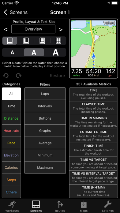

关于此应用
WorkOutDoors is the most advanced and most configurable workout app for the Apple Watch. It's perfect for running, cycling, hiking and any other indoor or outdoor activity.
Note: WorkOutDoors requires an Apple Watch Series 4 or later. It is not necessary to have your iPhone with you during a workout.
The app uses Apple’s workout system, so all workouts are saved to the Health system. However it also provides many extra features over Apple's app, such as:
- a super-smooth vector map that can be shown during a workout;
- multiple configurable screens with metrics and graphs from a pool of 800+ data fields;
- route files can be imported and used for navigation (including turn by turn directions);
- dozens of configurable alerts (e.g. every mile; high heart rate; low pace; off-route etc);
- interval schedules can be created using the larger screen of the phone app;
- climbs and descents are supported with notifications and on-screen data and graphs;
- waypoints can be created, navigated to, and exported;
- use shortcuts to associate operations with gestures (e.g. double tap to hear configurable metrics);
- compare pace against a target or a previous workout (using metrics and a dot on the map);
- show zones for pace and power as well as heart rate (with optional coloured backgrounds);
- auto-pause is available for all outdoor activities;
- shows GPS and heart rate before starting a workout, so that you can wait for good signals;
- configure distance and pace for running / walking to come from Apple’s pedometer or from GPS;
- workouts can be exported in FIT / TCX / GPX files, or automatically sent to Strava;
- workouts created by the app can be analysed in great depth in the iPhone app.
The app also has many more features. The map is a particular highlight. It uses OpenStreetMap, which provides worldwide coverage and includes the trails necessary for outdoor workouts. It also has several features that help you navigate during a workout:
- maps can be smoothly panned and zoomed, and can rotate according to the compass;
- a breadcrumb trail of your whole route is displayed on the map during the workout;
- topographic data can be shown, with configurable contour colours and hill shading;
- map-only mode is provided for when you don't want to start a workout and just need a map;
- a circular scale is shown when you zoom, making it easy to see the distance to features;
- maps can be stored on the watch for use when offline (they are downloaded as required if online);
- a red compass points north and a green compass points to the start;
- choose a waypoint to see a compass and distance to it in the corner of the map;
- you can also navigate to waypoints on the map, such as hospitals, sights, cafes etc.
If you load a route from a GPX / TCX / FIT file then navigation is even easier:
- your position is shown on an elevation profile of the route;
- the remaining distance, time and ascent can also be displayed;
- you can get alerted when you go off-route;
- when off-route then a compass is shown which points to the nearest part of the route;
- if the route contains turn by turn directions then these can be used like a sat nav;
- if there are no directions then the app can use “bend detection” to generate them;
- the next direction is shown as an icon and distance in the corner of the map;
- the map can automatically zoom in when you are approaching a turn;
- you can use shake gestures to hear the distance to the next turn or the end of the route;
- routes are coloured by gradient: from red for steep uphill to blue for steep downhill;
- you can configure what information is displayed during a climb or descent.
All this is included for a single one-off payment. No extra in-app purchases or subscriptions are required (although there is a completely optional in-app tip jar which was requested by long-term users).
If you own an Apple Watch and do any form of exercise, then WorkOutDoors is the app for you. Give it a go!
Note: WorkOutDoors requires an Apple Watch Series 4 or later. It is not necessary to have your iPhone with you during a workout.
The app uses Apple’s workout system, so all workouts are saved to the Health system. However it also provides many extra features over Apple's app, such as:
- a super-smooth vector map that can be shown during a workout;
- multiple configurable screens with metrics and graphs from a pool of 800+ data fields;
- route files can be imported and used for navigation (including turn by turn directions);
- dozens of configurable alerts (e.g. every mile; high heart rate; low pace; off-route etc);
- interval schedules can be created using the larger screen of the phone app;
- climbs and descents are supported with notifications and on-screen data and graphs;
- waypoints can be created, navigated to, and exported;
- use shortcuts to associate operations with gestures (e.g. double tap to hear configurable metrics);
- compare pace against a target or a previous workout (using metrics and a dot on the map);
- show zones for pace and power as well as heart rate (with optional coloured backgrounds);
- auto-pause is available for all outdoor activities;
- shows GPS and heart rate before starting a workout, so that you can wait for good signals;
- configure distance and pace for running / walking to come from Apple’s pedometer or from GPS;
- workouts can be exported in FIT / TCX / GPX files, or automatically sent to Strava;
- workouts created by the app can be analysed in great depth in the iPhone app.
The app also has many more features. The map is a particular highlight. It uses OpenStreetMap, which provides worldwide coverage and includes the trails necessary for outdoor workouts. It also has several features that help you navigate during a workout:
- maps can be smoothly panned and zoomed, and can rotate according to the compass;
- a breadcrumb trail of your whole route is displayed on the map during the workout;
- topographic data can be shown, with configurable contour colours and hill shading;
- map-only mode is provided for when you don't want to start a workout and just need a map;
- a circular scale is shown when you zoom, making it easy to see the distance to features;
- maps can be stored on the watch for use when offline (they are downloaded as required if online);
- a red compass points north and a green compass points to the start;
- choose a waypoint to see a compass and distance to it in the corner of the map;
- you can also navigate to waypoints on the map, such as hospitals, sights, cafes etc.
If you load a route from a GPX / TCX / FIT file then navigation is even easier:
- your position is shown on an elevation profile of the route;
- the remaining distance, time and ascent can also be displayed;
- you can get alerted when you go off-route;
- when off-route then a compass is shown which points to the nearest part of the route;
- if the route contains turn by turn directions then these can be used like a sat nav;
- if there are no directions then the app can use “bend detection” to generate them;
- the next direction is shown as an icon and distance in the corner of the map;
- the map can automatically zoom in when you are approaching a turn;
- you can use shake gestures to hear the distance to the next turn or the end of the route;
- routes are coloured by gradient: from red for steep uphill to blue for steep downhill;
- you can configure what information is displayed during a climb or descent.
All this is included for a single one-off payment. No extra in-app purchases or subscriptions are required (although there is a completely optional in-app tip jar which was requested by long-term users).
If you own an Apple Watch and do any form of exercise, then WorkOutDoors is the app for you. Give it a go!
详情
| 开发者 | CCS Ltd |
|---|---|
| 类别 | 健康与健身 |
| 价格 | 9,99 € |
| 年龄评级 | 4+ |
| 版本 | 6.4 |
| 大小 | 38.7 MB |
| 最低 iOS | 12.0 |
| 包 ID | net.workoutdoors.workoutdoors |
| 发布 | 2017-07-13 |
| 最后更新 | 2026-06-26 |
| 语言 | 1 语言 |
此页面回答的问题
- WorkOutDoors 应用评论
- WorkOutDoors 应用评级
- WorkOutDoors 下载
- WorkOutDoors 应用商店排名
- WorkOutDoors 评论
- WorkOutDoors 评论和评分
- WorkOutDoors 是否合法
- WorkOutDoors 是否是骗局
- WorkOutDoors 真实用户评论
- WorkOutDoors 评分
- WorkOutDoors 投诉
- 人们对 WorkOutDoors 的看法
- WorkOutDoors 应用 评论
- WorkOutDoors 优缺点
- WorkOutDoors 经验
- 我应该信任 WorkOutDoors 吗
- WorkOutDoors 反馈
- WorkOutDoors 评论 2026
- WorkOutDoors 检查
- WorkOutDoors 安全检查
