
MilGPS
Cascode Labs Pty Ltd Navigation 4+ £12.99
4.82 · 323 évaluations
Meilleure position maintenant
#30
à travers 4 vitrines
Pic
#21Jours suivis
52Évaluations
323 Historique des graphiques
52 jours enregistrés par nous
Vitrines
graphique en 4 aujourd'hui
Évaluations
323 sur l'App Store
Prix
changé 18 fois dans notre fenêtre
Installations et revenus
Apple ne publie rien — nous ne devinons pas
Actuellement dans le classement
Historique
Construit à partir des propres instantanés quotidiens d'Astrina — un point par jour.
Position dans le graphique — 🇺🇸 Meilleurs payants
23.07 23.08 24.09
Afficher les chiffres
| Jour | Position |
|---|---|
| 23.07 | #35 |
| 24.07 | #26 |
| 25.07 | #35 |
| 31.07 | #39 |
| 01.08 | #39 |
| 02.08 | #64 |
| 03.08 | #82 |
| 04.08 | #39 |
| 05.08 | #33 |
| 06.08 | #26 |
| 07.08 | #32 |
| 08.08 | #43 |
| 09.08 | #44 |
| 10.08 | #77 |
| 11.08 | #47 |
| 12.08 | #45 |
| 13.08 | #41 |
| 14.08 | #36 |
| 15.08 | #46 |
| 16.08 | #53 |
| 18.08 | #63 |
| 19.08 | #47 |
| 20.08 | #35 |
| 21.08 | #43 |
| 22.08 | #51 |
| 23.08 | #58 |
| 24.08 | #82 |
| 25.08 | #43 |
| 26.08 | #29 |
| 27.08 | #32 |
| 28.08 | #45 |
| 29.08 | #65 |
| 02.09 | #37 |
| 03.09 | #31 |
| 04.09 | #42 |
| 05.09 | #60 |
| 09.09 | #69 |
| 10.09 | #42 |
| 11.09 | #35 |
| 12.09 | #41 |
| 13.09 | #42 |
| 14.09 | #70 |
| 16.09 | #23 |
| 17.09 | #21 |
| 18.09 | #22 |
| 19.09 | #26 |
| 20.09 | #42 |
| 21.09 | #70 |
| 22.09 | #42 |
| 23.09 | #30 |
| 24.09 | #30 |
Nombre d'évaluations
02.09 14.09 24.09
Afficher les chiffres
| Jour | Évaluations |
|---|---|
| 02.09 | 5,523 |
| 03.09 | 5,523 |
| 04.09 | 5,523 |
| 05.09 | 5,524 |
| 09.09 | 5,525 |
| 10.09 | 5,525 |
| 11.09 | 5,525 |
| 12.09 | 5,526 |
| 13.09 | 5,526 |
| 14.09 | 5,527 |
| 16.09 | 5,527 |
| 17.09 | 5,528 |
| 18.09 | 5,528 |
| 19.09 | 5,529 |
| 20.09 | 5,528 |
| 21.09 | 5,529 |
| 22.09 | 5,529 |
| 23.09 | 5,531 |
| 24.09 | 5,532 |
Captures d'écran


À propos de cette application
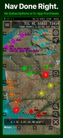
MilGPS is a field navigation tool designed for efficient use by trained navigators using MGRS coordinates. No in-app purchases or subscriptions.
OVERVIEW
- Display your current location and other info in large, clear text on customizable screens.
- Create waypoints using your current location, map crosshairs, distance/direction projection or optimized coordinate entry. Organize waypoints into overlays and navigate to them by following an arrow or on the map.
- Visualize your location and waypoints on a map with smooth scrolling grid lines/labels. Apple and Google online maps are included or supply your own offline maps in raster MBTiles format.
OTHER FEATURES
- Supports MGRS, USNG, UTM, Lat/Lon and OSNG location formats.
- Supports a wide variety of map datums including WGS84, NAD27, OSGB36, AGD66 and ED50.
- Use 3 different datums/location formats for location display and waypoint entry.
- Supports a wide variety of angle, altitude, and distance formats.
- Cell phone signal not required for basic navigation functionality. Online maps require a data connection.
- Supports military date time groups for local/zulu time
- Import and export waypoints via the standard GPX file format. Limited support for KML and CSV formats. Routes and tracks not supported.
- Map ruler tool to measure distance/direction between two points on the map, snaps to waypoints
NOT INCLUDED (YET)
- Route planning
- Track recording
- Online mapping sources other than Apple and Google maps
- Vector offline maps
QUESTIONS
[email protected]
NOTES
- WiFi-only iPads are not supported because they don't have a GPS receiver.
- Mapping function requires a data connection.
- Using GPS will shorten battery life.
- Online maps are provided, hosted and updated by third parties. Maps may be inaccurate or censored. Map types and quality may change without notice.
PRIVACY
Because you can choose to use Google maps in the app, we are required to disclose the data collected by Google in our App Store listing. If you do not use Google maps minimal data is collected. See our privacy policy for details.
WARNING
YOUR USE OF MILGPS IS AT YOUR OWN RISK
MilGPS is an aid to navigation only and is intended to be used in conjunction with other navigation methods and tools.
MilGPS must not be used where relying on MilGPS could result in death, injury or financial loss. This includes use on military operations, live-firing activities, aviation and surveying use.
MilGPS is not tested to military specifications and is not endorsed by the military of any nation. MilGPS is not a substitute for military issue equipment.
Your use of MilGPS is governed by the standard App Store Licensed Application End User License Agreement.
OVERVIEW
- Display your current location and other info in large, clear text on customizable screens.
- Create waypoints using your current location, map crosshairs, distance/direction projection or optimized coordinate entry. Organize waypoints into overlays and navigate to them by following an arrow or on the map.
- Visualize your location and waypoints on a map with smooth scrolling grid lines/labels. Apple and Google online maps are included or supply your own offline maps in raster MBTiles format.
OTHER FEATURES
- Supports MGRS, USNG, UTM, Lat/Lon and OSNG location formats.
- Supports a wide variety of map datums including WGS84, NAD27, OSGB36, AGD66 and ED50.
- Use 3 different datums/location formats for location display and waypoint entry.
- Supports a wide variety of angle, altitude, and distance formats.
- Cell phone signal not required for basic navigation functionality. Online maps require a data connection.
- Supports military date time groups for local/zulu time
- Import and export waypoints via the standard GPX file format. Limited support for KML and CSV formats. Routes and tracks not supported.
- Map ruler tool to measure distance/direction between two points on the map, snaps to waypoints
NOT INCLUDED (YET)
- Route planning
- Track recording
- Online mapping sources other than Apple and Google maps
- Vector offline maps
QUESTIONS
[email protected]
NOTES
- WiFi-only iPads are not supported because they don't have a GPS receiver.
- Mapping function requires a data connection.
- Using GPS will shorten battery life.
- Online maps are provided, hosted and updated by third parties. Maps may be inaccurate or censored. Map types and quality may change without notice.
PRIVACY
Because you can choose to use Google maps in the app, we are required to disclose the data collected by Google in our App Store listing. If you do not use Google maps minimal data is collected. See our privacy policy for details.
WARNING
YOUR USE OF MILGPS IS AT YOUR OWN RISK
MilGPS is an aid to navigation only and is intended to be used in conjunction with other navigation methods and tools.
MilGPS must not be used where relying on MilGPS could result in death, injury or financial loss. This includes use on military operations, live-firing activities, aviation and surveying use.
MilGPS is not tested to military specifications and is not endorsed by the military of any nation. MilGPS is not a substitute for military issue equipment.
Your use of MilGPS is governed by the standard App Store Licensed Application End User License Agreement.
Détails
| Développeur | Cascode Labs Pty Ltd |
|---|---|
| Catégorie | Navigation |
| Prix | £12.99 |
| Classification par âge | 4+ |
| Version | 7.24.1 |
| Taille | 45.5 MB |
| iOS minimum | 26.0 |
| ID de bundle | com.kvurd.milgps |
| Publié | 2010-12-01 |
| Dernière mise à jour | 2026-09-15 |
| Langues | 1 langues |
Ce que cette page répond
- MilGPS critiques d'application
- MilGPS évaluation d'application
- MilGPS téléchargement
- MilGPS classement de l'App Store
- avis sur MilGPS
- avis et évaluations de MilGPS
- est MilGPS légitime
- est MilGPS une arnaque
- avis d'utilisateurs réels de MilGPS
- évaluation de MilGPS
- plaintes concernant MilGPS
- ce que les gens disent de MilGPS
- avis MilGPS application
- avantages et inconvénients de MilGPS
- expérience de MilGPS
- devrais-je faire confiance à MilGPS
- retour d'expérience de MilGPS
- avis sur MilGPS 2026
- vérification de MilGPS
- vérification de sécurité de MilGPS
